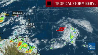
 PHILIPSBURG:--- At 5PM, the center of Tropical Storm Beryl was located near latitude 12.7 North, longitude 52.7 West or about 780 miles southeast of St. Maarten. Beryl is moving faster toward the west-northwest near 17 mph (28 km/h). Additional west north-westward motion with an increase in forward speed is expected during the next few days.
On the forecast track, the center of Beryl will approach the Lesser Antilles through Sunday, crossing the island chain on Sunday night. The center of Beryl is expected to pass about 122 miles south of St. Maarten sometime early Monday.
Maximum sustained winds have further decreased to near 50 mph (85 km/h) with higher gusts. Additional weakening is forecast during the next 48 hours, and Beryl is likely to weaken to a tropical depression after moving through the Lesser Antilles. This system could degenerate into an open trough by the time it reaches the central Caribbean Sea and Hispaniola on Monday night.
Beryl is a small tropical storm. Tropical-storm-force winds extend outward up to 45 miles (75 km) from the center. The estimated minimum central pressure is 1003 mb (29.63 inches).
Tropical Storm Beryl continues to weaken and that trend is expected to persist as it tracks toward the Lesser Antilles.
Beryl is tiny in size, but impacts are expected in the Lesser Antilles beginning Sunday.
A tropical storm warning has been issued for the islands of Dominica and Guadeloupe, while tropical storm watches are in effect for Barbados, St. Lucia, Martinique, St. Martin/St. Maarten, St. Barthelemy, Saba and St. Eustatius.
Tropical storm-force conditions, respectively, are possible in Barbados Sunday, and in the rest of the Windward Islands late Sunday into early Monday.
Its tropical storm-force winds extend only up to about 45 miles from its center.
Intensity forecasts with tropical cyclones as tiny as Beryl are notoriously difficult.
According to the National Hurricane Center (NHC), wind shear has increased and combined with a very dry environment likely causing Beryl to weaken.


