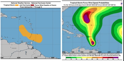
At 2:00 pm, the center of Tropical Storm Karen was located near latitude 15.5 north, longitude 65.2 west or about 226 miles south-southwest of St. Maarten.
Karen is moving toward the north-northwest near 12 mph (19 km/h), and this general motion is forecast to continue today. A turn toward the north is expected by Tuesday.
On the forecast track, the center of Karen will move across the eastern Caribbean Sea today. At its closest point, the center of Karen is forecast to pass about 175 miles west-southwest of St. Maarten on Tuesday morning.
Maximum sustained winds remain near 40 mph (65 km/h) with higher gusts. Karen could weaken to a tropical depression or degenerate into an open wave later today or tonight, however, little overall change in wind speed is expected over the next day or so.
Tropical-storm-force winds extend outward up to 105 miles (165 km) from the center. The latest estimated minimum central pressure reported is 1007 mb (29.74 inches).
Meteorological Department St. Maarten will continue to monitor the progress of this system and keep the public updated accordingly.
POTENTIAL IMPACTS FOR ST. MAARTEN:
Rainfall: Karen is expected to produce total rainfall accumulations of 1 to 4 inches. Increasing cloudiness with showers and thunderstorms are expected within the next 24 hours. Most of the significant showers are expected from tonight into Tuesday. Flooding and/or rockslides are possible in flood-prone areas and along hillsides. Residents and users of these areas are advised to be vigilant.
Winds: Gusty winds could accompany showers tonight through Tuesday.
Seas: Swells up to 9 feet are possible, mainly along the southern coast, during the passage of Tropical Storm Karen. These swells are likely to cause life-threatening surf and rip current conditions. Beach erosion is possible in vulnerable areas. Small craft operators should exercise extreme caution and sea- bathers are advised to stay away from the sea.
 PHILIPSBURG:--- Growing amounts of moisture and instability associated with the approaching outer bands of Tropical Storm Karen will account for increased cloudiness and shower activity. Some of these showers may be heavy and accompanied by thunder, especially during the latter part of the forecast period.
A small craft advisory remains in effect for St. Maarten as above-normal seas continue across the region. Small craft operators and sea bathers should exercise extreme caution.
STATE OF THE SEA: Moderate to rough
WAVES/SWELLS: 6 to 9 feet
SPECIAL FEATURES:
1. At 11:00 am, the center of Tropical Storm Karen was located near latitude 14.9 north, longitude 64.8 west or about 244 miles south-southwest of St. Maarten.
Karen is moving toward the north-northwest near 12 mph (19 km/h), and this general motion is forecast to continue today. A turn toward the north is expected on Tuesday.
On the forecast track, the center of Karen will move across the eastern Caribbean Sea today. At its closest point, the center of Karen is forecast to pass about 175 miles west-southwest of St. Maarten on Tuesday morning.
Maximum sustained winds remain near 40 mph (65 km/h) with higher gusts. Little overall change in strength is forecast during the next 48 hours.
Tropical-storm-force winds extend outward up to 105 miles (165 km), mainly northeast through southeast of the center.
The latest estimated minimum central pressure reported is 1007 mb (29.74 inches).
2. Tropical Depression 13 became Tropical Storm Lorenzo at 11am, where it was located near 11.1N 24.1W or about 2650 miles east-southeast of St. Maarten, moving West at 18 mph.
Maximum sustained winds are near 40 mph (65 km/h) with higher gusts.
A motion toward the west-northwest is expected starting tonight, and this is forecast to continue through the middle of the week.
On the forecast track, the center of the depression should pass well over 1000 miles east of St. Maarten on Saturday.
Additional strengthening is forecast, and Lorenzo is expected to become a hurricane by Wednesday.
The Meteorological Department of St. Maarten will continue to monitor the progress of these systems and update the public accordingly.


